Get the weekly SPARTANAT newsletter.
Your bonus: the free E-Book from SPARTANAT.
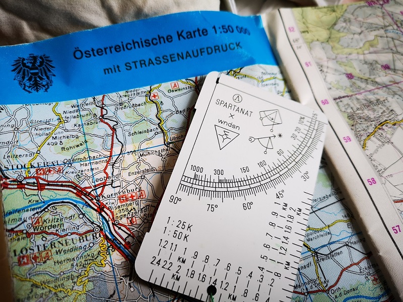
REVIEW: The SPARTANAT Planimeter Telemeter
The text discusses the Planimeter-Telemeter developed in cooperation with WNDSN, detailing its features and applications for measuring distances on maps efficiently. It highlights the significance of this tool for outdoor activities and concludes with information on availability for purchase.

Today our first own review. We want to introduce to you our Planimeter-Telemeter, which we developed in cooperation with WNDSN, in detail. When using the Mil/MOA Range Calculators (link to our review), we had a few ideas on how to further improve this magnificent tool and make it even more versatile.
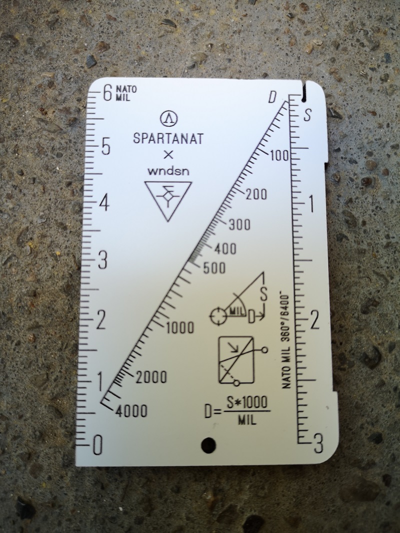 And this is the result: The front side of the Planimeter-Telemeter in all its glory. In the end, you have a small calculation aid station.
On the left side, you will find a scale in Strich or MIL, which is probably the most widely used size in Europe to measure small angles. On the right side, you will see the scale with sizes/units. Most likely, you will use meters, but in principle, this calculator is unitless.
In the middle diagonal, you will find the result scale, which indicates the distance of the object. If you want to double-check, the underlying MKS formula is also printed, where "D" stands for distance and "S" for the size of the object. It is also noted very small that 360° correspond to 6,400 Strich.
 The view through the Recce Pro HD from Vortex Optics. You see a tractor that is about three Strich long. Now we can calculate the distance using the formula, assuming that the tractor is 4.5m long. Or you can use the front side of the Planimeter-Tel... In the video we show you this in more detail.
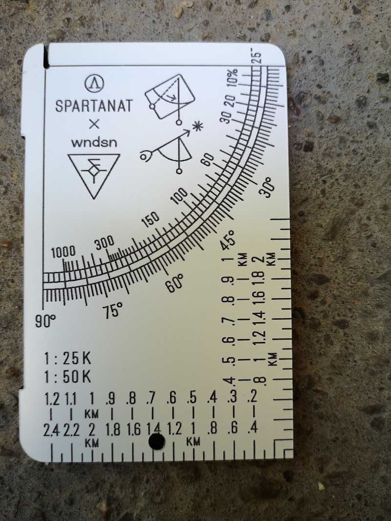 The back of our Planimeter-Telmeter. As the name suggests, you will find a planimeter for the scales 1:50,000 and 1:25,000. This covers the most common map scales. There is also a angle scale. The reading units available are degrees, percent, and Strich. The Strich scale is located between the degree and percent scales and is divided into 100 Strich and 25 Strich.
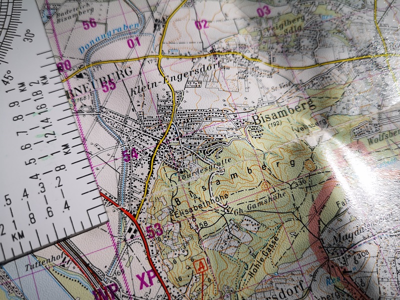 For everyone who doesn't know what a Planimeter is, you can measure or transfer coordinates from a map. As an example, we want to measure the coordinates of the Lourdes Grotto. To do this, we hold the planimeter to our target and align it parallel to the fine grid lines. Then we just have to read the values.
 As seen in the previous image, the Grotto is located somewhere in box 01/53. Now we want to read the exact location. First, we determine the distance of the map point to the vertical lines.
Our point is very close, so we read it as 50m. Then we go "up the tree" and read about 550m. So the coordinate of the Lourdes Grotto is 01050 and 53550. Compared to the GPS, we measured it quite well. If you have GPS coordinates, you can also transfer them to the map. We show you how in the video.
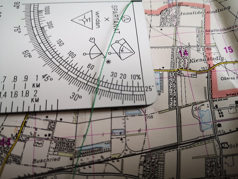 With the angle scale, you can do more than just measure slope angles. With some thought, you can transfer or measure marching numbers on the map, all without a compass.
CONCLUSION: Our Planimeter Telemeter is a clever and very valuable addition to the outdoor EDC. For anyone who handles maps and often needs to determine distances, the SPARTANAT/WNDSN Planimeter Telemeter is a practical companion to ensure reaching your destination efficiently, a tool with heads that helps you efficiently in field map work.
For those convinced and finding it as brilliant as we do, the "SPARTANAT/WNDSN Planimeter Telemeter" is available exclusively in our SPARTANAT Shop for 37 euros.
WNDSN on the internet: wndsn.com
SPARTANAT Shop on the internet: shop.spartanat.com
SPARTANAT is the online magazine for Military News, Tactical Life, Gear & Reviews.
Send us your news: [email protected]
Ad
similar
Get the weekly SPARTANAT newsletter.
Your bonus: the free E-Book from SPARTANAT.